Westside Area Plan
You’ve probably heard some hullabaloo about the Westside Area Concept Plan either in the Hood River News here, here, or here or from your friends and neighbors.
So far the Westside Plan consultants have generated more than 900 pages (!) of traffic simulations, road routes and elevations, housing projections, infrastructure funding scenarios, bike and pedestrian projects, Cascade Avenue makeovers, etc., etc., etc. It is a big complex project with lots of detail but we firmly believe that we plan better with robust public participation.
In order to help folks get a sense of the issues, Thrive and our friends at Livable Hood River hosted a couple of informational forums on a variety of aspects of the plan like housing, parks, bicycle and pedestrian trails, and integrating nature into urban neighborhoods. You can check out videos of the presentations here.
Frequently Asked Questions:
What is the Westside Area Plan?
The Westside Area Plan is an effort by the City of Hood River to plan for the future of 450-acres of emerging neighborhoods on the west side of town between Rand and Frankton by doing a comprehensive area plan. The Plan will create a vision for the growth and livability of the Westside area and address land use, zoning, streets, bikeways, pedestrian paths, parks, schools, utilities, and infrastructure funding. Increasing the diversity and supply of workforce and affordable housing is a specific goal of the project. The project is funded by an integrated land use and transportation planning grant from the Transportation Growth Management Program of Oregon Department of Transportation and Department of Land Conservation and Development and our executive director served as the grant writer for the project.
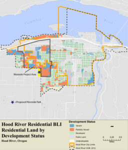
The Westside area contains the majority of undeveloped land in the City. Hood River did this map of their inventory of buildable lands in 2015 as part of their Housing Needs Analysis. We call it the “map of the future” because it shows where Hood River is going to grow. The blue and red shading is for vacant or partially vacant land. The yellow property is the much-needed Westside Park we proposed in 2016. While there will be building in other parts of the city over the next 20 years, the majority of new housing will go where there is raw land available to build– Hood River’s Westside. With or without any major zoning changes, this area is where you should expect most growth to occur.
Why do it?
The 450-acre Westside Area was originally planned 34 years ago (1983) and those plans have not been updated even though a lot has changed in three plus decades. Hood River’s population has nearly doubled. There is not a single park in the Westside Area and the existing code and map don’t call for any to be built. We strongly feel that parks are an essential part of neighborhood livability. If we just stayed with the current Transportation System Plan the future school on Sherman would be fronted by a three-lane arterial road elevated 15 feet above the grade of the school. We can do better than that! By planning ahead of development, we’ve got our best shot to make these new neighborhoods into beloved parts of our city.
Where are we in the process?
After seven Technical Advisory Committee and Project Advisory Committee meetings, two public open houses and two online surveys, the consultant team led by Joe Dills of Angelo Planning, produced a Concept Plan Report. The report offers research and recommendations on all aspects of land use for the Westside project area from where the roads should go to how to zone for housing and how to pay for infrastructure.
Right now, the Concept Plan is just that—a concept—until its elements are adopted and implemented by the City. The adoption phase goes through the Planning Commission then the City Council with many opportunities for public input and revision. Here is the Planning Commission and City Westside Plan schedule.
The public is highly encouraged to be involved during this part of the process. Get on the City’s mailing list for notices of Westside Plan meetings.
What is the vision for the Westside Area?
Working with the consultants the Technical and Project Advisory Committees came up with a vision statement for the area. While some community members have expressed concerns about various aspects of the draft Concept Plan, we have heard near universal support for the vision. The trick will be turning the vision into reality:
Westside Area Plan Vision
The Westside Area will grow to become an interconnected community of great neighborhoods, an attractive gateway of commercial and mixed use activity, and an affordable and diverse area of the City. The Westside’s hallmarks will be:
- Housing options that provide choices for all income levels, life stages, and cultures within Hood River
- Streets, trails, and paths that are walkable, connected, and green
- Neighborhood design that celebrates the landforms, views, and magnificent landscape of Hood River
- Open spaces and parks that support community gathering and a connection to nature
The Westside Area will be an integral part and extension of the larger Hood River community.
What does the Thrive think of the plan?

We believe that proactive, comprehensive planning leads to better places. Since the Westside area contains the majority of the city’s unbuilt land, it seems like the right time to plan so that these emerging neighborhoods are great places to live.
“Do we support the Westside Plan?” The plan is a work in progress. It’s not a done deal nor is it anywhere near done. We support the vision for the community laid out in the plan but there is a big step between an appealing vision and implementation strategies that will achieve the vision.
We were on the Project Advisory Committee and advocated strongly for livable, walkable neighborhoods and diverse housing choices. We will continue to do our best to thoughtfully study the proposals, provide input and push for strategies that will effectively implement the vision.
This process is about hammering out a good plan with a lot of public participation. We encourage folks to find out more and get involved.
Is the plan just about density and zoning? What about bike trails, parks and nature?

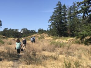
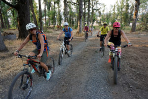
No! While discussions about whether to change zoning has got the lion’s share of attention, housing is only one part of a neighborhood. The Westside Area Plan is an opportunity to build in the kind of amenities that the public has said again and again they really want. One of the goals of the project is to get people out of their cars and encourage walking and biking. We invited the community to go on walk and bike audits of the Westside. And they worked. The City’s consultants recommended two new off-road trails be created—one north-south along Henderson Creek and an east-west trail along the ridge above Cascade. A great system of trails and bikeways will make living in these neighborhoods more healthy, environmentally friendly and fun. The plan also makes changes to our transportation plan, including some new streets.
We also see the plan as an opportunity to plan to a build nature-rich city that integrates parks, trails, streams and wetlands, fish and wildlife habitat, urban forests and greenspaces with the built environment.
What You Can Do:
Our community is better when we plan it together. This is a public process and we are less than halfway through. There is plenty of time for interested citizens to impact and improve the project. First, go to the project website and spend a little time exploring the proposals under consideration. Get on the project mailing list to make sure you learn about upcoming meetings and get all the project materials. You can make your thoughts known to the project team by sending them to Senior Planner, Kevin Liburdy.
We also want to hear from you. What do you like about Westside Area Concept Plan proposals? What worries you? What could be better? Are there things that the plan should address but doesn’t? If you’ve got questions or comments, send them to our email info@thrivehoodriver.org
